Permafrost in Alaska
Permafrost is defined as any ground material (such as soil, rock and ice) that remains at or below 0°C (32°F) for two or more consecutive years (IPA, 1998). The upper soil layer overlying permafrost that thaws seasonally in the summer and freezes in winter is known as the active layer. It is in this upper thawed layer that makes cultivation possible in areas with permafrost. In Alaska, mean permafrost temperatures range from around -10 °C (14 °F) in the northernmost parts of the state to just below freezing in areas more south (Romanovsky et al., 2017).
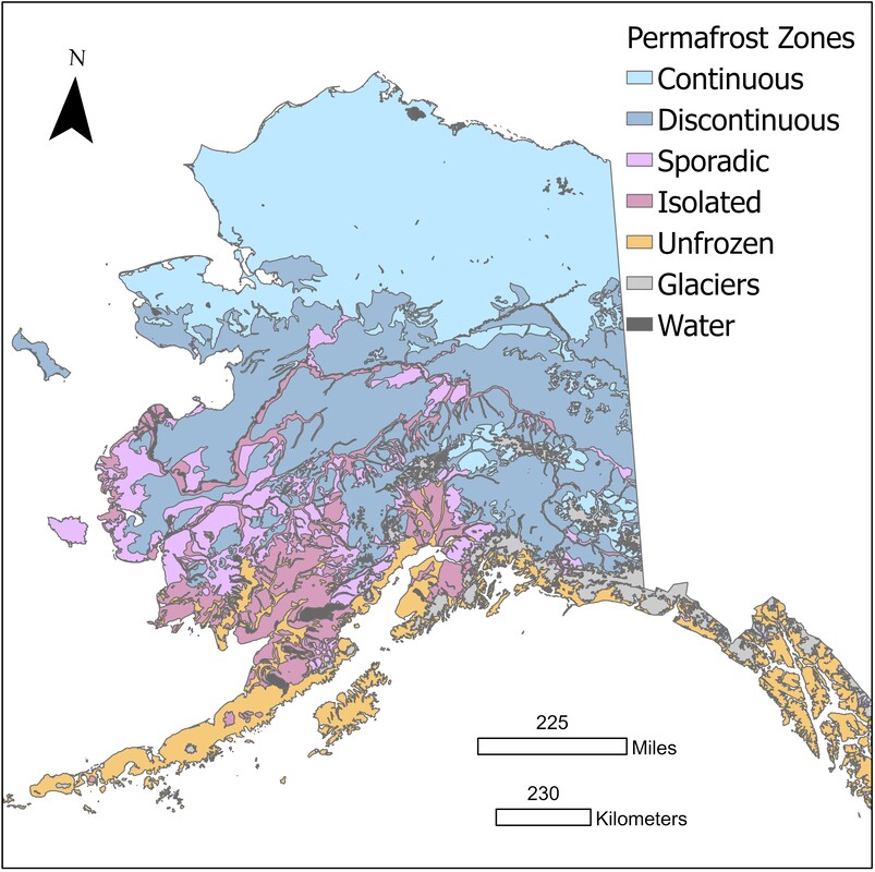
Map of permafrost zone in Alaska. Map was created using ArcGIS Pro 2.7 (©ESRI) with geospatial files from Jorgenson et al., 2008.
|
Permafrost Zones in Alaska Approximately 80 % of the state of Alaska is underlain by permafrost (Jorgenson et al., 2008). Permafrost in the state spans different zones that describe its lateral continuity. The figure on the left shows its distribution in Alaska. Continuous permafrost is found in the northern most parts of the state and covers 90- % to 100 % of land area. Discontinuous permafrost covers 50- % to 90 % of land area and is found within the middle region. Sporadic and isolated permafrost is found in the southern parts of the state and each span 10 % to 50 % and areas with <less than 10 %, respectively. Regions within the discontinuous, sporadic and isolated zones exist as a mosaic with permafrost-free areas. Permafrost in these areas was formed under a previous colder climate and are now preserved by ecosystem protection (Shur and Jorgenson, 2007), including vegetation (such as spruce trees), surface cover (such as peat) and aspect (permafrost is more likely to occur on north-facing slopes).
|
Ground Ice Distribution in Alaska
|
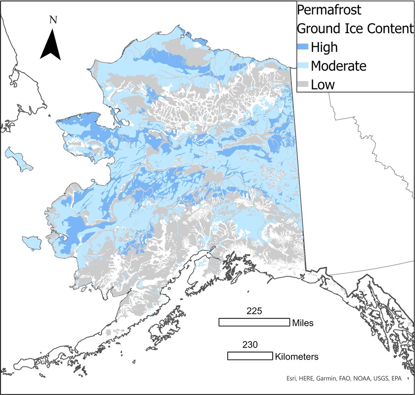
Map of ground ice distribution within permafrost in Alaska. Map was created using ArcGIS Pro 2.7 (©ESRI) with geospatial files from Jorgenson et al., 2008 and borders outline base map accessed on ArcGIS Pro 2.7.
|
Video Demonstrating Varied Responses to Thaw Based on Permafrost Ground Ice Content

An example of an ice wedge exposure in the CRREL Permafrost Tunnel Research Facility in Fox, AK. Toddler for scale.
|

Ground surface topography mapped with our project LiDAR drone at a field site in Fairbanks, AK. The 'honeycomb'-like surface texture are composed of multiple mounds (see header on top of page as example) that are created when ice wedge ice (see on right for example) melts. This type of permafrost thaw can lead to agricultural field abonnement.
|
To learn more about agriculture in Alaska click the button below:
Page References:
- International Permafrost Association, (1998). Multi-Language Glossary of Permafrost and Related Ground-Ice Terms. Edited by R.O van Everdingen. Calgary: Arctic Institute of North America. Version 2.0
- Jorgenson, T., Yoshikawa, K., Kanevskiy, M., Shur, Y., Romanovsky, V., Marchenko, S., Grosse, G., Brown, J., and Jones, B., (2008) Permafrost Characteristics of Alaska - 2008 Shapefile. North Slope Science Initiative. Access: https://catalog.northslopescience.org/dataset/1725
- Romanovsky, V. E., S. L. Smith, Ketil Isaksen, N. I. Shiklomanov, D. A. Streletskiy, A. L. Kholodov, H. H. Christiansen, D. S. Drozdov, G. V. Malkova, and S. S. Marchenko., (2017). Terrestrial permafrost. NOAA Arctic Report Card 2017.
- Shur, Y. L., and Jorgenson, M. T., (2007). Patterns of permafrost formation and degradation in relation to climate and ecosystems. Permafrost and Periglacial Processes, 18(1), 7-19.
- Ward Jones, M., Schwoerer, T., Gannon, G., Jones, B.M., Kanevskiy, M.Z., Sutton, I., St. Pierre, B., St. Pierre, C., Russell, J., and Russell, D., (2022) Climate-driven expansion of northern agriculture must consider permafrost. Nature Climate Change 12: 699–703.
|
|
The funding for this project is from the US National Science Foundation’s Navigating the New Arctic initiative under RISE award 2126965. |

|
This project was also supported by the University of Alaska Fairbanks. UA is an AA/EO employer and educational institution and prohibits illegal discrimination against any individual: www.alaska.edu/nondiscrimination. |